The general aim of the model and data is to understand the water behaviour in the massif – distribution, movement, quality, reactions, etc. The first part of the study is to understand the flow distribution, followed by conservative transport and reactive transport. The task thus addresses relevant issues related to modeling the long-term radionuclide transport in fractured hard rocks.
In the hydraulic model, the modelling issue and challenge is mostly in transition from discrete fractures to equivalent continuum (finding reasonable scale of inhomogeneity in the model according to available data) related to distribution of water inflow.
The conservative transport model is linked to the natural tracer data, and is used to estimate the water residence time. In the first step, the standard approach of lumped parameter models fitting the single inflow data is used. In the second step, a 2D or 3D advection model is planned, to include the particular flow field configuration at the site and to cross-validate the transport model with the hydraulic model.
The third step, reactive transport modelings, has a similar sequence, from fitting the laboratory (batch) experiments of granite leaching with general geochemical models, to reactive transport (possibly 1D) models with site-specific geometric and hydraulic data fitted to composition of particular inflow water in the tunnel.
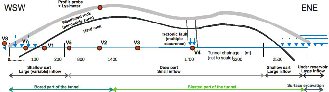
Profile of the tunnel with basic hydrogeological features and some measurement points.
The purpose of work is to combine information on water movement in granite from all the above processes and data and validate the models by checking them against each other. The problems follow the previous hydraulic models within the earlier Decovalex-2011 project (Hokr et al, 2013, 2014).
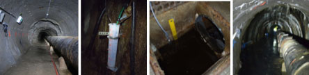
Photos of selected places in the tunnel: boundary of bored and blasted parts with bare rock, measurement of single discharge flow rate, measurement of canal flow rate (water level), part with shotcrete cover with larger water inflow.
Experimental Data
The tunnel is located in the north of the Czech Republic, in the Jizera mountains, part of the Bohemian massif, Krkonoše-Jizera Composite Massif. The tunnel was excavated during 1980-1981, connects a water reservoir with a water processing plant, is 2600m long in maximum 150m depth, with the first 890m excavated with a tunnel boring machine and the remaining part by drill-and-blast.
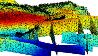
Example of former numerical model of flow in the site (Decovalex-2011 test case, Hokr et al 2014) – combined 3D and 2D domains.
The site is important as one of the few underground spaces in hard host rock available for research in the Czech Republic. The research related to the nuclear waste repository started in 2003, with support of SURAO, lead by Josef Klomínský from Czech Geological Survey (Klominsky and Woller, 2010). Many interdisciplinary geoscientific studies were conducted with participation of several other institutes with fracture mapping, geophysics, and laboratory rock sample analyses used as background for the TC study. Hydrogeological and geochemical studies were extended from 2009 by the Technical University of Liberec – automatic measurement of individual water discharge places, flow rate in the collection canal and natural tracer sampling and analyses. The natural tracer data are further supported by the nearby experimental watershed site Uhlirska of Czech Technical University Prague (lead by Martin Sanda, reference Dusek et al, 2012).
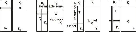
Particular model configurations for D-2015 test case, representing selected real positions in the tunnel – view of 3D models lateral and transversal to the tunnel.
Approach
We consider a model without exact terrain shape, representing a part of the tunnel in the particular depth (figure). The concept includes an effect of mixing water between slow flow through the rock matrix (small fractures) and quicker flow through a fracture/fault and then a division of shallow more permeable zone and deep less permeable rock, necessary to balance the difference of infiltration and tunnel inflow to a unit length of the tunnel. This concept is used both for hydraulics and tracer transport. The following particular models/steps are planned to be solved:
steady-state models of flow with average inflow used (calibration of hydraulic conductivity and check of models between the teams)
lumped-parameter model interpretation of natural tracers (stable 2H and 18O, tritium-helium decay) – coarse estimation of residence time
transient hydraulic model – reaction of inflow to changing infiltration, more precise calibration of conductivity and interaction between the shallow and the deep zones
tracer transport in 3D – common calibration of hydraulic parameters and porosity/apertures, with fictitious pulse tracer (optionally) and with the real 2H and 18O sequences
optionally 1D models of reaction of infiltrated water with rock minerals, fitting the tunnel inflow ion composition
evaluation of residence time and other parameter determination uncertainty – comparing models from continuously rising data sequences (measured during the project)
Participating Groups
Czech Republic: SURAO / Technical University of Liberec
Germany: BGR
USA: Department of Energy (Sandia Labs)
Further Information
For further information, please contact the task leader, Milan Hokr (milan.hokr@tul.cz)
References
Klomínský J., Woller F. (eds.) (2010): Geological studies in the Bedrichov water supply tunnel. RAWRA Technical Report 02/2010.– 103 p., Czech Geol. Survey, Prague. ISBN 978-80-7075-760-4
Hokr M., Balvín A., Škarydová I., Rálek P. (2014), Tunnel inflow in granite - fitting the field observations with hybrid model of discrete fractures and continuum, In (Sharp and Troeger, eds) Groundwater in Fractured Rocks, 13 pages, to appear 2014
Hokr M., Skarydova I., Frydrych D. (2013) Modelling of tunnel inflow with combination of discrete fractures and continuum, Comput. Vis. Sci. 15 (1), 21-28.
Dusek J, Vogel T, Sanda M (2012), Hillslope hydrograph analysis using synthetic and natural oxygen-18 signatures, Journal of Hydrology, Volume 475, pp 415-427.